Walks & Parks
-

Rotorua - Hannahs Bay
This large, flat area lies between Rotorua airport and the shores of Lake Rotorua. There is an all mobility playground, horse bridle trial and a dog exercise area. The reserve has large open spaces for recreational activities and the beach is popular for swimming and windsurfing. There are toilets, BBQs and picnic tables.
read more -

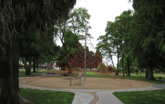
Island Bay
Island bay is surrounded by small bays with calm, clear waters. Between the beach and the Parade is Shorland Park. Popular with local children, the park has a long slide, swings, pirate ship, junior area and basketball half-court. There are also picnic tables, changing sheds and toilets
read more- Location: Opposite Island Bay Beach
-

Te Apiti Wind Farm - Palmerston North
The views from here are worth the visit, on clear days you can see as far as Mt Ruapehu, Mt Taranaki and out across the horizon. You can stand directly beneath a turbine and read all about how they work. With giant turbine blades whirring overhead, these surreal machines are quite a spectacle to behold.
read more- Location: Woodville 4999
-

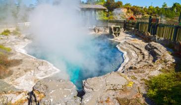
Rotorua - Hot Water Beach
This beach on the southern shores of Lake Tarawera is only accessible by boat and there is a ferry that can take you across from Boat Shed Bay. Hot Water Beach is administered by the Department of Conservation. There is a self-registration, user pays, camping area on site and you can bathe in the hot mineral waters that are around 38 degrees, so take your swimsuit. There are toilets on site.
read more- Location: Lake Tarawera
-

Waipu Cove
Nine kilometers south of Waipu, Waipu Cove has a white sandy beach which is popular for swimming and surfing. The east side of the cove offers safer swimming for small children. There are toilets, picnic tables, BBQ's as well as convenience stores and cafes. Lifeguards patrol part of the beach during the summer.
read more- Location: South of Waipu, off SH1
-
Taupo -Tongariro Domain
Tongariro Domain has a playground which is suitable for children and there are picnic tables. The Domain’s toilets also offer a parents’ room with a changing table and microwave, sink and toys for the children. The Lion’s Club operates children's rides on the Domain on a small monorail, weather permitting, for $1 per person. Check with the Visitor Centre for train times during the winter months.
read more- Location: Tongariro Road, Lakefront, Taupo
-

Blue Lake Loop - St. Bathans
There are a couple of options around the Blue Lake area in St. Bathans - the 2km, 50 min option will take you on a loop that skirt a portion of Blue Lake. A 3km, 90min return option will take you all the way around Blue Lake.
read more-
Location:
Blue Lake
St Bathans 9386
-
Location:
Blue Lake
-

Biking - McLeans Island
Part of the Waimakariri River Regional Park, the McLeans Track is a well-built, smooth 10km mountain bike track that is ideal for family biking. There are plenty of twists and turns, bumps and small ups and downs, to make it great fun, without being too technical. Ideal for beginner bikers or family groups! Plenty of parking at the start of the track, and there's also a cabin open at weekends, selling bottled water, drinks, muffins and other goodies. You can even rent bikes (for both kids and adults) and helmets, at the start of the track (weekends only, or by arrangement from On Your Bike - 03 348 1738).
read more- Location: Opposite Orana Wildlife, McLeans Island Road, off Johns Road, Christchurch
-

Stirling Point - Bluff
If you’ve got this far, it’s a must to visit the southernmost point on NZ’s mainland – Stirling Point. It’s marked by a signpost telling you just how far you are from most of the world’s major cities. There are toilets and a restaurant/café at Stirling Point. Foveaux Walkway 50 minutes return. The coastal track from Stirling Point to Lookout Point has a gravelled and well-compacted surface, which can be used by buggies, although it is uneven in places. Glory Track a 50 minute round trip from Stirling Point, follows the track up the hill behind the restaurant. At the top of the hill you can see gunneries, and then continue walking from the Gunpit entrance around to Stirling Point.
read more- Location: Bluff - Stirling Point
-

Hoon Hay Scenic Reserve
This spot is easily missed when travelling down summit road as It's not very well sign posted ! But being only a short 5 minute walk I would definitely recommend stopping. It's one of the best views of Governors Bay/ Lyttelton Harbor I've seen (yet) Travel to this spot using the GPS coordinates below, it will take you to a grass 'carpark', follow the grass foot path up the hill, but keep an eye out as there's a small turn off that's easily missed. Take a picnic and relax, let the kids explore.
read more- Location: 2016 Summit Rd, Kennedys Bush, Christchurch 8971
-

Devils Punchbowl Walking Track - Arthur's Pass
Feel the full force and sound of fresh mountain water falling 131 m down one of New Zealand’s most stunning waterfalls. It's one of our best short walks. 2 km return via same track- 1 hr return. The track starts at the northern end of Arthur's Pass village, just off SH73 at the Punchbowl car park (signposted off the highway). From the start of the walk, follow the footbridge across the Bealey River. The next bridge, over Devils Punchbowl Creek, has a good view of the waterfall. From here, wander through lush beech forest with friendly fantails/pīwakawaka and tomtits before climbing 150 m up a series of steps to a viewing platform at the base of this spectacular waterfall. Return on the same track.
read more- Location: Northern end of Arthur's Pass village, just off SH73 at the Punchbowl car park
-

Ruakuri Walkway - Waitomo
The 45 minute return journey is over a well-constructed track which passes through picturesque rain forest and limestone landscale with excellent views of the Ruakuri Natural Tunnel (a remnant cave). There are picnic tables and toilets at the start of the walk.
read more- Location: 3 Kilometres from Waitomo Museum, off Tumutumu Road
-

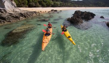
Lake Hayes Recreation Area - Queenstown
Consists of sandy beach, warm shallows, lots of space and toilets. Great spot to picnic and relax on a sunny day - lots of shade. Pontoon and good swimming and kayaking.
read more- Location: Queenstown - 15km from Queenstown - leave town via Frankton. Lake Hayes is on your left. Turn left at the turn off for Arrowtown - the best picnic area is signposted 2km along the Arrowtown road at the head of the lake.
-

Lake Kaniere Short Walks
These short (2-15min) forest walks lead to picnic areas, waterfalls and sandy beaches ideal for swimming - plenty to keep kids interested. The beach at the end of Canoe Cove Walk and Dorothy Falls are spots for swimming. Dorothy Falls is refreshing but a little chilly!
read more- Location: Dorothy Falls Rd, Kokatahi 7881
-

Rere Falls
A very picturesque waterfall that makes a great picnic spot. The falls are only 5m high, but 20m wide.
read more- Location: Wharekopae River, Gisborne, Rere 4072
-

Piha Beach
All the beaches on this stretch of the West Coast are black iron sand beaches. The safest place for swimming for children is at low tide in the Blue Pool off The Gap. The main beaches are not recommended for young children to swim in as they are primarily surf beaches. Nearby is the Piha Domain which contains toilets and a camping ground and is a great place for picnics.
read more -

Hawkes Bay - White Pines Bush
29km north of Napier on SH2, native bush walk with educational panels, native birds and forest. The reserve has huge kahikatea, dwarfing the tawa and pukatea that provide most of the remaining tree cover. Nikau palms are also an attraction. Hanging vines, shrubs and ferns proliferate under the tree canopy, providing habitat for native birds including tui, kereru (native pigeons), fantails, bellbirds, silver-eyes, grey warblers and ruru (morepork). Boardwalks make it easy with buggies and there are two walks to choose from – 30 minutes or 1 hour. Toilets and picnic area.
read more- Location: SH2, 29km north of Napier
-

Oparara Basin short walks
These short, easy walks feature limestone arches, caves with critters and a tarn with reflections of the surrounding rainforest - plenty to keep kids interested. Crazy Paving Cave (10 min return) take a torch and follow a short bush track to the cave entrance. Be extra careful not to step off the track and not to step on any of the large spiders that live in the cave.The unusual floor pattern was created over long period of time from deposits of mud which have dried out forming paving patterns on the cave floor. Take a look at the ceiling – another example of nature’s art. Box Canyon Cave (10 min return) At the end of the main track, carefully descend the steps to the cave. Explore its blocky recesses in complete freedom and take a hard look at the ceiling for fossils - look but don’t touch. Cave dwellers such as weta, spiders, and bettles live in the darkness. Have a look at these interesting insects, but be careful not to disturb them. Mirror Tarn (30 min) a sign points along a bush track toward this secretive spot. A pool full of dark water reflects tall trees and rich birdsong fills the air. Here you are called on to joyfully reflect on the foresight of a local bushman who noted the rimu trees around the tarn had been tagged for felling and his successful argument to have the beauty preserved. Oparara Arch (25 min, one way) From the first car park a well-formed track leads up the Oparara riverbank, through beech and podocarp forest and past limestone outcrops. The arch is 219 metres long with sides 79 metres apart and a roof 43 metres above the river that carved the impressive feature.
read more-
Location:
11km north of Karamea on the road to Kohaihai. Then 12km to the arches car park and another 3km to the caves car park. Kahurangi National Park 7073
-
Location:
11km north of Karamea on the road to Kohaihai. Then 12km to the arches car park and another 3km to the caves car park. Kahurangi National Park 7073
-

Clay Cliffs
The kids will love walking to explore these staggering natural land forms; sharp pinnacles and ridges separated by narrow ravines. The Clay Cliffs are a geological wonder; sharp pinnacles and ridges separated by steep and narrow ravines. The Cliffs are relatively new, made up of layers of silt and gravel deposited by ancient glaciers over a million years ago. To get to the Clay Cliffs, turn onto Quailburn Rd off SH8 and then onto unsealed Henburn Rd. The cliffs are on private land, so please respect the property and obey all signage. Park a bit further back and make it more of walk.
read more- Location: Quailburn Rd off SH8, Nr Omarama
-

Hagley Park
Expansive parkland (around 160 hectares) in central Christchurch, Hagley Park public reserve is totally flat and a perfect escape from city life, without leaving the city. Drive in off Rolleston Avenue – there’s plenty of parking, a licensed café and information centre. Nearby is a large playground, lake and extensive gardens. There are walking, cycling or rollerblading tracks throughout the park and indoor/outdoor Botanic Gardens. Numerous recreation areas provide tennis courts, rugby fields, fitness track, netball courts and cricket pavilion. Look out for open air concerts during summer.
read more- Location: Christchurch - city centre
-

Yarndley’s Bush - Waikato
A short walk of about 30 minutes return will take you along a board-walked track and through 14 hectares of Kahikatea forest. There is a viewing tower half-way around the track where you can see the canopy layers within the bush.
read more- Location: off Ngaroto Road, off State Highway 3
-

The Esplanade Picnic Area - Queenstown
A favourite spot, only minutes from the town centre. There’s lots of space as the picnic area runs alongside the lake for about 1km. Close to playground and toilets.
read more- Location: Queenstown - The Esplanade
-

Nelson Creek, Grey Valley - Greymouth
On State Highway 7, going inland from Greymouth, there’s a turnoff to Nelson Creek Recreation Reserve between Stillwater and Ahaura. There is a carpark and camping available, and a number of short bush tracks exploring the site of the 1865 Nelson Creek goldrush. Sluicing and dredging continued until 1900. Evidence of tailraces, tunnels, tailings, and a water race remain and the historic Colls Dam can be visited. Other features include a swing bridge and ancient beech forest.
read more -

Matarangi Beach
The seaside at Matarangi is perfect for families with its gentle surf and safe swimming and four and a half kilometers of white sandy beaches. There is a store and café nearby.
read more- Location: Halfway between Whitianga and Coromandel town
North Island
South Island
- Central Otago
- Auckland
- Bay of Plenty
- Christchurch
- Dunedin
- Coromandel
- Gisborne
- Fiordland
- Hawkes Bay
- Marlborough Sounds
- Manawatu
- Nelson & Golden Bay
- Northland
- North Canterbury
- Queenstown
- Rotorua
- South Canterbury
- Taranaki
- Southland
- Taupo
- Wanaka
- Waikato
- Wellington
- West Coast
- Whangarei
- Bay of Islands
- Tauranga
- Gisborne
- Hamilton
- Napier
- Kapiti
- Palmerston North
- Whanganui
- New Plymouth
- Arrowtown
- Te Anau
- Akaroa
- Ashburton
- Hanmer
- Kaikoura
- Methven
- Mt Cook
- Oamaru
- Tekapo
- Timaru
- Abel Tasman
- Motueka
- Nelson Lakes
- Blenheim
- Picton
- Catlins
- Gore
- Stewart Island
- Central Plateau
- Invercargill
- Cromwell
- Greymouth
- Hokitika
- Westport
- Glenorchy
Our favourite destinations…